
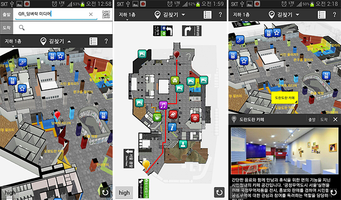
Seoul Metropolitan Government rolled out the mobile app informing the facility information in the halls and route plan through its 3D indoor map. (image: Seoul Metropolitan Government)
SEOUL, Korea, April 30, 2014 (Korea Bizwire) – Mr. Kim who came to the Seoul Citizens Hall to enjoy a concert turned on a smartphone app called “Seoul Citizens Hall” at the entrance of the hall. As soon as he took the QR code placed in the entrance, he was positioned in the 3D indoor map of the app.
By setting Baseurak Hall, the concert venue, as his destination, the app showed the route to the place and estimated arrival time. With the app, he could easily find the way to the concert hall although he was a total stranger. Like this, the Seoul Metropolitan Government rolled out the mobile app informing the facility information in the halls and route plan through its 3D indoor map on April 29.
Noticing that citizens are suffering from inconveniences due to complicated facilities in the hall with more than 20 rooms and halls for exhibitions, concerts and other gatherings in the two basement floors, the city government introduced the indoor route-planner app expecting its citizens and tourists can use its facilities conveniently with the app as an information map.
Although there are many navigation and route planner apps in the app stores, it is still the baby step in case for searching routes indoors. The “Seoul Citizens Hall” app is the first instance offering an indoor route planner service through the 3D map from the actual images.
With the 3D map, users can check the facilities without visiting the real places. For the project, Seoul hired 157 youths aged younger than 39 who joined a “New Deal” job offering project last year. Besides the citizens hall, they created 3D indoor maps of 105 subway stations, 56 public buildings and two underground shopping malls in Seoul.
The city government expects that if the indoor route planner app is applied to other big and complicated buildings like mega shopping malls, Seoul citizens can get easier accesses to those buildings.
Meanwhile, the local government will open the database of the 163 indoor 3D maps to the public at the end of this year for the further development of the services with the maps. In the long-term aspect, the city government expects that with integration of other IT technologies like indoor position measurement, the maps will create new businesses and promote security of the citizens in case of accidents like fire.
An official at the Seoul government said, “The 3D indoor map not only offers convenience and useful information to citizens but informs escape routes and exits in case of a crisis. We will expand the indoor map databases and open it to the public for other usage for various industrial developments.”
Written by John Choi (johnchoi@koreabizwire.com)
Technology (Follow us @Technews_Korea)


Pingback: Seoul City Gov’t Rolls out 3D Indoor Route Planner App