
Technology that can be used to create a 3D map by simply walking around with a backpack has been developed by a Korean research team. (Image : Yonhap)
SEOUL, Jan.20 (Korea Bizwire) – Technology that can be used to create a 3D map by simply walking around with a backpack has been developed by a Korean research team.
Professor Do Rak-ju (40) and his team at Korea University’s Department of Electronic Engineering reported that they had succeeded in developing technology that records images of indoor space and distance information quickly to create a three-dimensional map.
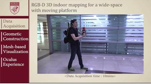
A backpack-shaped device equipped with laser sensors, gravity sensors and cameras realize the indoor images.
By walking around inside Seoul Station wearing the device, the inside of the station is mapped on the device’s computer.
The camera records images, and sensors measure the distance and formation of objects in the image.
Unlike 3D maps made outdoors using GPS, creating 3D maps of indoor environments has been difficult in the past.
The research team said that its technology is more cost and time efficient than alternatives when creating detailed indoor maps, such as the inside of cultural heritage sites.
The researchers also noted that complete 3D maps can be created through the technology unlike ‘road view’ maps provided by portal sites, which connect 2D images to give an impression of a 3D environment.
In addition, unlike Samsung Project Beyond and Google Jump, which are similar technologies, the new method can create maps while the subject is moving.
The results of the research were published in the journal ‘IEEE Robotics and Automation Letters’.
Four patents have been applied for, and seven are currently pending.
Officials at Korea University explained that the technology was transferred to a location-based services business, and will be commercialized in the near future.
By Kevin Lee (kevinlee@koreabizwire.com)


Bel Fiore Bridal – Atlanta’s most beautiful wedding …